System Requirements:
PC-based attendees
NAPSG's Webex platform
For more information on systems requirements Click Here.
Instructors:
Milton Ospina, HERE
Milton has been actively involved in the GIS industry since 1988. He spent 15 years working at Esri as a software intructor and Industry Marketing Manager. Mr. Ospina joined HERE, a Nokia Business, in 2008 as Business Development Manager. In 2004 he co-authored Measuring Up: The Business Case for GIS book (Esri Press) and in 2007 he co-authored Mapping for Congress: Supporting Public Policy with GIS: Library of Congress, Congressional Cartography Program (Esri Press.)
Mr. Ospina is a frequent US and international speaker on the use of GIS for urban planning, community development, and the critical role high-quality GIS map databases play in the development of Enterprise GIS Systems.
Peter O'Rourke, NAPSG Executive Director
Question?
Peter O'Rourke National Alliance for Public Safety GIS Foundation
202-895-1711
porourke@publicsafetygis.org
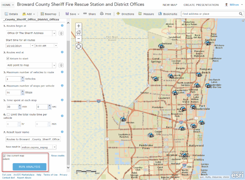
The National Alliance for Public Safety GIS Foundation and HERE are co-hosting a virtual training to provide the public safety and GIS community with training on how to use ArcGIS Online and HERE data to achieve more efficient routing for public safety. This virtual training is a great opportunity for individuals that are new to the technical aspects of GIS for public safety and are seeking to develop foundational skills. It is also ideal for individuals interested in learning how to use ArcGIS Online and HERE data to support day-to-day public safety operations involve basic routing functions.
- Learn how to complete the routing process – routing is a type of network analysis that determines the best route from one network location to one or more other locations
- Learn how to apply routing features to determine time efficiency in an operational law enforcement scenario
- Learn how to overlay imagery with HERE map content
- Learn how to use real-time HERE traffic data to determine time efficiency in routing options
- And much more!
Who Should Attend?
- GIS Analysts, Specialists, and Managers
- Information Technology professionals that support public safety
- Public Safety professionals interested in gaining basic GIS skills – Emergency Managers, Fire Service, Law Enforcement, Search & Rescue, Mass Care, Public Health, and others